Welcome to Utileyes
Drone Inspection Made Easy
Streamline your aerial power line inspections—from flight to final report—with our easy-to-use drone inspection software.
Powerline Inspection Drone Software That Works for You
Utileyes Inspections is your all-in-one platform for managing drone utility inspection workflows—whether you’re running a turnkey aerial utility inspection or building an internal program for long-term savings and control.

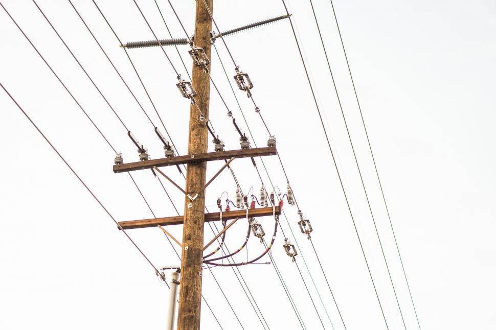
Between coordinating pre-flight plans, managing UAV pilots, organizing data from drone electrical inspection photos, and aligning those results with GIS and work order platforms—inspections can quickly become overwhelming. Utileyes streamlines this process.
We provide drone utilities with the most flexible, user-friendly, and scalable software for utility inspection. Our drone powerline inspection tool was built based on feedback from top utility inspection companies. From mapping and pilot delegation to thermal drone image review and reporting, Utileyes handles it all.
We support your team whether you’re flying thermal drones, i-hawk systems, ihawk UAVs, or any combination. The result: faster inspection cycles, better data accuracy, and lower costs for power line inspections.
Inspection Tracking
Never miss a critical inspection again. Our comprehensive tracking system shows you what’s been inspected, what’s due soon, and what needs immediate attention—all in a simple, color-coded interface that makes prioritization intuitive.
Geospatial Intelligence
Visualize your entire utility network on interactive maps. Utileyes plots all inspection data geographically, allowing you to identify patterns, prioritize maintenance, and optimize resource allocation with just a few clicks.
Streamlined Workflow
Utileyes transforms the chaotic process of managing drone inspection footage into a seamless workflow. Our intuitive platform organizes all your utility pole data in one place, giving your team instant access to critical information when they need it most.
Why choose Utileyes?

Cost Reduction
Lower your operational expenses while improving inspection quality and coverage.

Effortless Organization
End the chaos of scattered files with a centralized platform for all your inspection data.

Improved Reliability
Catch potential failures before they cause outages with AI-assisted issue detection.

Rapid Implementation
Get up and running quickly with minimal IT overhead and straightforward user onboarding.

Great software should make life easier for the people in the field—not just look good in a demo.
Built for Utilities. Designed by Experience.

Utileyes Inspections was created with one mission: to revolutionize how utility companies perform drone-based inspections. We’re a team of utility veterans, drone experts, and software developers who came together to build something purpose-driven. After years of working in the utility industry, we knew that traditional inspection processes were inefficient, error-prone, and often relied too heavily on outdated software and manual reporting.
Our journey began on the front lines—with linemen in the field, utility inspectors logging photos manually, and operations managers struggling to make sense of disorganized data. We saw firsthand how aerial utility inspections using drone technology had potential—but the software to support it simply wasn’t good enough. That’s why we built Utileyes.
We’ve created a drone inspection software platform that simplifies the inspection process for power lines, distribution equipment, substations, and more. Our platform supports both thermal drone imagery and traditional visual data, all organized and prepared for efficient inspection and reporting.
What sets us apart is our user-first approach. Unlike other utility inspection companies that offer bloated tools packed with features no one uses, Utileyes was built to be lean, intuitive, and actionable.
We believe the best utility pole inspection software is built not only with innovation—but with empathy for the people using it.
Use Cases
Electric Utilities
Electric utilities face significant challenges when it comes to the routine inspection of poles, transformers, substations, and overhead lines. With aging infrastructure and growing demands for reliability, it’s critical that these inspections be both comprehensive and efficient. Utileyes enables powerline drone inspection workflows that scale—from local co-ops to national utilities. Using thermal drones, UAVs, or i-hawk systems, inspections are faster and more accurate, with reporting that feeds directly into your outage and maintenance planning tools.
Telecommunications
From fiber infrastructure to 5G towers, telecom companies use drone electrical inspection to monitor their network’s health. Utileyes’s drone utility inspection platform enables high-resolution data capture, precise anomaly detection, and repeatable inspection criteria to maintain network uptime and minimize safety hazards. Our software integrates with existing tower management systems and helps prioritize maintenance by severity.
Renewable Energy
Solar farms, wind turbines, and battery storage sites benefit greatly from aerial utility inspection using thermal drone capabilities. Hotspot detection, mechanical failure, and vegetation encroachment can all be identified through our inspection workflows.
Municipal Infrastructure
Cities and towns rely on drones for utility inspection of streetlights, water towers, bridges, and other public assets. Our system supports distribution equipment inspection software for public works teams who need to quickly capture data and trigger repairs. Easily assign inspections to internal staff or contractors, and generate reporting that ties into budgeting and asset management systems.
Rail & Transportation
Railroads and transportation agencies use Utileyes to inspect crossings, rights of way, and overhead lines. Drone power line inspections in these environments help improve safety while reducing the need for boots-on-the-ground risk. With full photo traceability and data export into maintenance planning tools, our drone inspection software helps ensure compliance, safety, and operational uptime.
Our Process
![]()
![]() Upload or Generate a Mapping File
Upload or Generate a Mapping File
Start with a KML/CSV file or let the software auto-create a map using flight data. This is ideal for powerline inspection drone programs without full GIS support.
![]()
![]() Assign Pilots with a Click
Assign Pilots with a Click
Visually assign inspection assets using our map interface. Great for teams managing multiple aerial utility inspection routes.
Download Custom Flight Plans
Export pilot-specific maps compatible with UAV systems including ihawk and i-hawk.
Fly & Capture Images
Execute your aerial power line inspection, capturing high-resolution or thermal drone images.
Upload Photos Automatically
Our system recognizes GPS metadata and auto-organizes by asset. Perfect for high-volume drone utilities.
Quality Assurance
Mismatched photos are flagged and pre-sorted for fast reassignment. This reduces manual sorting time for large-scale utility inspection projects.
Inspect & Tag Anomalies
Use our best utility pole inspection software tools to categorize by severity. Adjust inspection forms on the fly.
Export & Report
Generate real-time CSV files or pull executive-level insights from our dashboards. Easily share with platforms like ARC GIS, ESRI or the Collector App.
Our 8-step workflow has been optimized for utility teams doing drone power line inspections, UAV inspections, and distribution system checks. It adapts to field realities while maintaining a clear digital chain of command.


Featured Article
-
Revolutionizing Utility Pole Inspections: How Drone Technology is Changing the Game
The utility industry stands at a crossroads. With aging infrastructure across the country and increasing demands for reliability, utility companies face mounting pressure to maintain and inspect millions of utility poles efficiently. Traditional inspection methods—involving bucket trucks, climbing crews, and manual documentation—have served the industry for decades. But in today’s data-driven world, these approaches are…
GET IN TOUCH